
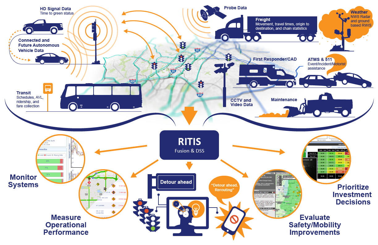
RITIS is the leading big data aggregation and dissemination platform for solving challenging and complex transportation problems.
Its broad spectrum of advanced analytics – from comprehensive situational awareness to in-depth archived data evaluation – provides enhanced, multi-faceted insight of the transportation system across geographic and agency boundaries.
RITIS is used nationwide by thousands of decision-makers in planning, operations, research, the military and Homeland Security for developing smart, cost-effective mobility, safety and security solutions.
| Data Types | Description |
|---|---|
| Traffic volume, speed, class, and occupancy from sensors (loops, RTMS, Video detection, Sensys pucks, etc.) |
Information collected by agencies and third parties from roadway sensors that could include inductive loops, side-fired sensors (acoustic, microwave, etc.), radar, and video.
This also includes data from probe-based systems—either agency-owned (Bluetooth) or third-party supplied (HERE Technologies, INRIX, TomTom.) |
| Event, work zone, and incident information | Information entered by each agency into its own incident management system. Data typically include incident location, type, severity, information about the vehicles involved and their status, to whom are notifications made and which responders are on-scene, which lanes are closed, response plans or detours, and messages on dynamic message signs (DMS) or Highway Advisory Radio (HAR). |
| Crowdsourced Waze data | Data provided by public users of the popular waze application can supplement data produced by DOT ATMS platforms and public safety CAD systems. These data include the location of collisions, disabled vehicles, debris, congestion, and other events that impact traffic flow and traffic safety. |
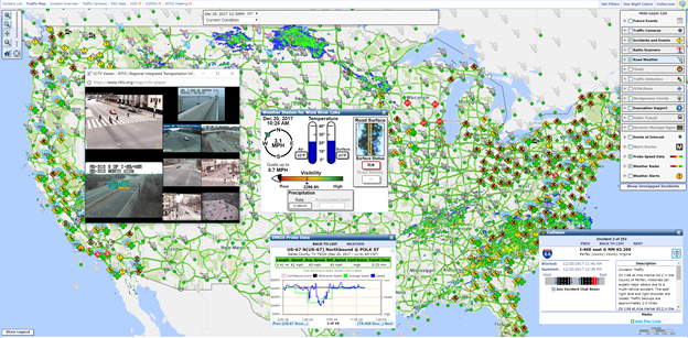
| Weather data | Weather alerts, temperature, precipitation types and rates, wind speeds, radar data, and other information from the National Weather Service, third parties, the media, etc. Also includes weather and pavement surface conditions that agencies gather from their roadway weather information systems (RWIS). |
| Device operational status | Data on the operational status of roadway devices from each agency, including traffic detectors, DMS, traffic signals, HAR, roadway weather information systems, and closed circuit television (CCTV) cameras, where available. |
| Managed lane status | Data on when high-occupancy vehicle (HOV) restrictions are in effect, direction of reversible lanes by time of day, and price of high-occupancy toll lanes by time. |
| Surveillance video | Live CCTV feeds focused on roadways, assets, or pedestrians. |
| Transit alerts | Transit alerts, service disruptions, and other information transmitted by transit providers—both public and private. |
| Automated vehicle locations (AVLs) | The locations and status of freeway service patrols, transit vehicles, or other assets equipped with AVL hardware. |
| Signal status | Operational status of signals at intersections or ramp meters, such as operational, maintenance mode, flashing, or offline. |
| Signal timing plans | Signal Phase and Timing plans (SPAT), current or future timing schemes, HD Signal data (at 10 hz or higher) |
| Computer-aided Dispatch (CAD) information | Data from public safety CAD systems, such as fire, emergency medical services (EMS), and law enforcement. Can include dispatch requests, incident types, severity, responder requests, or even lane status. |
| Static, descriptive information | Any information on roadway infrastructure, evacuation routes, business locations, permanent asset locations, or transit characteristics. For transit, this includes schedules, routes, and stops. For roadways, it includes information such as number of lanes, weight and height restrictions, speed limits, evacuation routes, and location of intelligent transportation system (ITS) devices. It can also include the location of schools, businesses, and other points of interest like dams, fueling stations, etc. |
| Decision-support response plans | The various actions that the departments of transportation (DOTs) are likely to take to help minimize congestion impacts and clear roads more quickly. Could include pre-programmed DMS messages, signal timing plans, traveler information strategies, detours, etc., that are grouped together into a single, cohesive “plan of action” ready to implement. The sharing of these response plans can help agencies to better coordinate so that one agency’s response plan is not in conflict with another’s. |
| Parking data | Location of parking facilities, number of spaces occupied and available, time and duration of parking space utilization, current fees, restrictions, and data on how to reserve a space. |
| Travel time | Often a derivative of speed data, travel time data represent the number of minutes it takes a person to travel from one location to another. Travel times are often divided into road segments where the start and end point of the segments are intersections or key features such as bridges or tunnels. Vehicle travel time data can be derived from point sensor speed data. It also can be directly measured by probes, such as license plate recognition, toll tag transponders, Global Positioning Systems, and cell phone tracking. Alternatively, it can be estimated and predicted from other data sources. |
| Freight movements | Mixture of data related to the origin-destination (O-D) of various shipments or types of shipments, statistics on the type of goods being shipped, the mode by which the goods are shipped, value of the goods, quantity of goods, type of shipping container, and safety records. |
| O-D and Trip data | Tells operations personnel and planners where trips begin; where they end; and, sometimes, the routes that are taken. These data can be valuable for planning purposes and are useful for real-time operations when trying to measure the impact of various traveler information strategies and the impact of incidents on arterials and other secondary roads. Private data aggregator services routinely make O-D data anonymous. |
| Routing data | Data that can be used by both emergency first responders and the traveling public to determine the fastest route, shortest path, etc., from one point to another. Comprised of road network data, turning restrictions, speed limits, and other information related to route types and distances. |
| CV/AV Data | Data can include Basic Safety Message (BSM) data related to braking, trajectory, etc. data. Can also include more detailed vehicle event data including—ABS engagement, traction control engagement, air bag deployment, wiper use, headlight use, emissions information, fuel consumption, seatbelt use, and more. |
— MPO Senior Transportation Analyst
— DOT Planner
— DOT Consultant
— DOT Operations Manager
— Center Operations Engineer
— Private Sector Public Information Officer and Media Relations for a DOT


 Agency Guided
RITIS enhancements and new features are continually guided by agencies through Agency Input Sessions in regularly scheduled RITIS and Probe Data Analytics Suite User Groups,
as well as suggestions, comments and questions sent to our Support Team.
This has ensured that user interfaces, output formats, and visualizations reflect agency priorities and needs.
Agency Guided
RITIS enhancements and new features are continually guided by agencies through Agency Input Sessions in regularly scheduled RITIS and Probe Data Analytics Suite User Groups,
as well as suggestions, comments and questions sent to our Support Team.
This has ensured that user interfaces, output formats, and visualizations reflect agency priorities and needs.
 Data agnostic
RITIS tools can ingest nearly any type of data in any format. Our probe data analytics tools work with any 3rd party probe data provider
(HERE, INRIX, or TomTom.) If an agency decides later to change their ATMS, ITS technologies, or data provider, rest assured that historic data
will be preserved—providing seamless analysis between data providers and time ranges.
Data agnostic
RITIS tools can ingest nearly any type of data in any format. Our probe data analytics tools work with any 3rd party probe data provider
(HERE, INRIX, or TomTom.) If an agency decides later to change their ATMS, ITS technologies, or data provider, rest assured that historic data
will be preserved—providing seamless analysis between data providers and time ranges.
 Tailored for inter-agency collaboration
There is great value to “seeing” across jurisdictional boundaries.
For daily operations, significant events, and regional emergencies, coordination improves when everyone has access to a single,
trusted source of information. Dedicated preparedness and collaboration tools built into RITIS help agency and responder staffs
plan, train, execute, and review together.
Tailored for inter-agency collaboration
There is great value to “seeing” across jurisdictional boundaries.
For daily operations, significant events, and regional emergencies, coordination improves when everyone has access to a single,
trusted source of information. Dedicated preparedness and collaboration tools built into RITIS help agency and responder staffs
plan, train, execute, and review together.
 Shared development & pooled fund projects
When one agency invests in a new feature or technology, the products are shared so all other RITIS agencies can benefit.
By leveraging each other’s investments, agencies accomplish more with less while helping the system to evolve.
Shared development & pooled fund projects
When one agency invests in a new feature or technology, the products are shared so all other RITIS agencies can benefit.
By leveraging each other’s investments, agencies accomplish more with less while helping the system to evolve.
 Maintained and improved by a large professional support team
RITIS is developed and supported by an unparalleled interdisciplinary team of graphic artists, UX specialists, transportation professionals,
IT staff, software developers, and agency partners, making it a powerful national asset.
Maintained and improved by a large professional support team
RITIS is developed and supported by an unparalleled interdisciplinary team of graphic artists, UX specialists, transportation professionals,
IT staff, software developers, and agency partners, making it a powerful national asset.
